.png

We collected localization traces from a radio interferometric tracking system, which is implemented on mote-class wireless sensor nodes.
last modified : 2007-07-18
release date : 2007-06-06
date/time of measurement start : 2006-11-29
date/time of measurement end : 2006-11-29
- Categories:
 84 Views
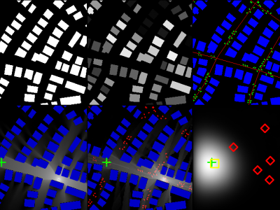
This dataset contains pathloss and ToA radio maps generated by the ray-tracing software WinProp from Altair. The dataset allows to develop and test the accuracies of pathloss radio map estimation methods and localization algorithms based on RSS or ToA in realistic urban scenarios. More details on the datasets can be found in the dataset paper: https://arxiv.org/abs/2212.11777.
- Categories:
2641 Views
The simulated InSAR building dataset contains 312 simulated SAR image pairs generated from 39 different building models. Each building model is simulated at 8 viewing-angles. The sample number is 216 of the train set and is 96 of the test set. Each simulated InSAR sample contains three channels: master SAR image, slave SAR image, and interferometric phase image. This dataset serves the CVCMFF Net for building semantic segmentation of InSAR images.
- Categories:
634 Views
In the era of increasing connectivity, everything including upcoming medical devices is being connected to the internet. These medical devices are monitoring units which measure application specific parameters, process them, perform data encoding and send them to a cloud server. Intravenous (IV) therapy is a common medical procedure which requires a continuous monitoring of the setup to avoid complications which can be achieved by running the system for hours. Traditionally, doctors and nurses use their experience to estimate the time required by an IV to run.
- Categories:
189 Views
HazeRD is an outdoor scene dataset for benchmarking dehazing algorithms. HazeRD contains 10 different scenes based on the architectural biometrics project. For each scene, the ground RGB images, depth maps, and synthesized hazy images following the atmospheric optics are provided; the hazy images come with five different haze level using real life physical parameters. The main features of HazeRD to other dehazing datasets are: HazeRD focuses on outdoor scenes whereas other datasets provide indoor scenes; and, the synthesis is based on real life parameters.
- Categories:
2307 Views