Computer Vision

SeaIceWeather Dataset
This is the SeaIceWeather dataset, collected for training and evaluation of deep learning based de-weathering models. To the best of our knowledge, this is the first such publicly available dataset for the sea ice domain. This dataset is linked to our paper titled: Deep Learning Strategies for Analysis of Weather-Degraded Optical Sea Ice Images. The paper can be accessed at: https://doi.org/10.1109/jsen.2024.3376518
- Categories:
 27 Views
DIRS24.v1 presents a dataset captured in campus environment. These images are curated suitably for the utilization in developing perception modules. These modules can be very well employed in Advanced Driver Assistance Systems (ADAS). The images of dataset are annotated in diversified formats such as COCO-MMDetection, Pascal-VOC, TensorFlow, YOLOv7-PyTorch, YOLOv8-Oriented Bounding Box, and YOLOv9.
- Categories:
46 Views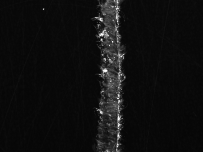
The foundation of detection relies on the surface micro-defect images of KDP, and the effectiveness of the detection model depends on the quality of these images. Higher quality images can pinpoint the shape details and boundary features of defects, thereby enhancing the overall detection capability.
- Categories:
54 Views
the first digitalized mammogram dataset for breast cancer in Saudi Arabia, depend on the BI-RADS categories, to solve the availability problem of local public datasets by collecting, categorizing, and annotating mammogram images, supporting the medical field by providing physicians with different diagnosed cases especially in Saudi Arabia
- Categories:
101 Views
For the semantic segmentation to be effectively done, a labelled flood scene image dataset was created. This initiative was undertaken with official permission obtained from the BBC News Website and YouTube channel, providing a valuable dataset for our research. We were granted permission to use flood-related videos for research purposes, ensuring ethical and legal considerations. Specifically, videos were sourced from the BBC News YouTube channel. The obtained videos were then processed to extract image frames, resulting in a dataset comprising 10,854 images.
- Categories:
72 Views
The Colour-Rendered Bosphorus Projections (CRBP) Face Dataset represents an innovative advancement in facial recognition and computer vision technologies. This dataset uniquely combines the precision of 3D face modelling with the detailed visual cues of 2D imagery, creating a multifaceted resource for various research activities. Derived from the acclaimed Bosphorus 3D Face Database, the CRBP dataset introduces colour-rendered projections to enrich the original dataset.
- Categories:
193 ViewsThis work presents a new labeled dataset of videos with native and professional interpreters articulating words and expressions in Libras (Brazilian Sign Language). We used a methodology based on related studies, the support of the team of articulators, and the existing datasets in the literature.
- Categories:
197 Views
The "Thaat and Raga Forest (TRF) Dataset" represents a significant advancement in computational musicology, focusing specifically on Indian Classical Music (ICM). While Western music has seen substantial attention in this field, ICM remains relatively underexplored. This manuscript presents the utilization of Deep Learning models to analyze ICM, with a primary focus on identifying Thaats and Ragas within musical compositions. Thaats and Ragas identification holds pivotal importance for various applications, including sentiment-based recommendation systems and music categorization.
- Categories:
200 Views
The Partial Discharge - Localisation Dataset, abbreviated: PD-Loc Dataset is an extensive collection of acoustic data specifically curated for the advancement of Partial Discharge (PD) localisation techniques within electrical machinery. Developed using a precision-engineered 32-sensor acoustic array, this dataset encompasses a wide array of signals, including chirps, white Gaussian noise, and PD signals.
- Categories:
115 Views
To test the feasibility of the idea: Using the processed data of sentinel-2 and GlobeLand30 as the input image and ground truth of subspace clustering for land cover classification, a dataset named 'MSI_Gwadar' is created.
'MSI_Gwadar' is a multi-spectral remote sensing image of Gwadar (town and seaport, southwestern Pakistan) and its four regions of interest, which includes MATLAB data files and ground truth files of the study area and its four regions of interest.
- Categories:
164 Views