Aerial imagery dataset
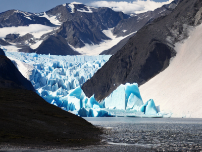
The temporal variability in calving front positions of marine-terminating glaciers permits inference on the frontal ablation. Frontal ablation, the sum of the calving rate and the melt rate at the terminus, significantly contributes to the mass balance of glaciers. Therefore, the glacier area has been declared as an Essential Climate Variable product by the World Meteorological Organization. The presented dataset provides the necessary information for training deep learning techniques to automate the process of calving front delineation.
- Categories:
 94 Views
In the wake of marine oil exploration and transportation, the accidents of oil spills have occurred
frequently around the world, which leads to the severe pollution of the marine environment and the
huge damage of coastal species [1–6]. On April 20, 2010, the explosion of Deepwater Horizon oil
drilling platform led to a severe leakage. Million barrels of oil polluted the Gulf of Mexico with the
area of about 10,000 square kilometers [7, 8]. Due to this accident, the marine ecosystems, such as fish
- Categories:
325 Views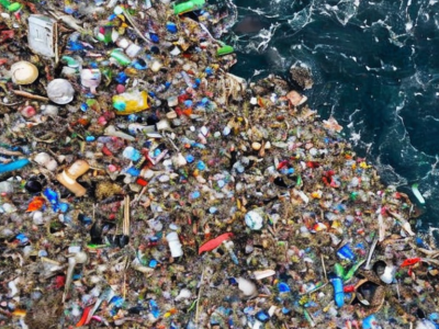
urrently, a significant amount of research is focused on detecting Marine Debris and assessing its spectral behaviour via remote sensing, ultimately aiming at new operational monitoring solutions. Here, we introduce a Marine Debris Archive (MARIDA), as a benchmark dataset for developing and evaluating Machine Learning (ML) algorithms capable of detecting Marine Debris.
- Categories:
204 Views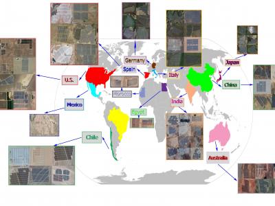
Extracting the boundaries of Photovoltaic (PV) plants is essential in the process of aerial inspection and autonomous monitoring by aerial robots. This method provides a clear delineation of the utility-scale PV plants’ boundaries for PV developers, Operation and Maintenance (O&M) service providers for use in aerial photogrammetry, flight mapping, and path planning during the autonomous monitoring of PV plants.
- Categories:
1326 Views