indoor positioning
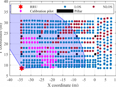
Channel frequency response (CFR) dataset used for "In-Situ Calibration of Antenna Arrays for Positioning With 5G Networks" paper (IEEE Transactions on Microwave Theory and Techniques, in print, doi: 10.1109/TMTT.2023.3256532, preprint link: https://arxiv.org/abs/2303.04470).
- Categories:
 1618 Views
The Bluetooth 5.1 Core Specification brought Angle of Arrival (AoA) based Indoor Localization to the Bluetooth Standard. This dataset is the result of one of the first comprehensive studies of static Bluetooth AoA-based Indoor Localization in a real-world testbed using commercial off-the-shelf Bluetooth chipsets.
The positioning experiments were carried out on a 100 m² test area using four stationary Bluetooth sensor devices each equipped with eight antennas. With this setup, a median localization accuracy of up to 18 cm was achieved.
- Categories:
1024 Views
This is a CSI dataset towards 5G NR high-precision positioning,
which is fine-grained, general-purpose and 3GPP R18 standards complied.
The corresponding paper is published here (https://doi.org/10.1109/jsac.2022.3157397).
5G NR is normally considered to as a new paradigm change in integrated sensing and communication (ISAC).
- Categories:
5442 Views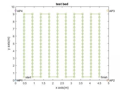
Data are collected on a 5m×10msized test bed, which is set up at Kadir Has University,Istanbul. Wireless access points are located around the corners of the testbed and markers are placed at every 45 cm. RSSI measurements done on the grid shown in Figure are stored via NetSurveyor program running on a Lenovo IdeapadFLEX 4 laptop, which has an Intel Dual Band Wireless-AC8260 Wi-Fi adaptor.At each measurement point, RSSI data are collected for1 min with a sampling interval of 250 ms.
- Categories:
777 Views
This dataset contains thousands of Channel State Information (CSI) samples collected using the 64-antenna KU Leuven Massive MIMO testbed. The measurements focused on four different antenna array topologies; URA LoS, URA NLoS, ULA LoS and, DIS LoS. The users channel is collected using CNC-tables, resulting in a dataset where all samples are provided with a very accurate spatial label. The user position is sweeped across a 9 squared meter area, halting every 5 millimeter, resulting in a dataset size of 252,004 samples for each measured topology.
- Categories:
5832 Views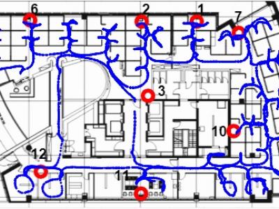
Dataset used for "A Machine Learning Approach for Wi-Fi RTT Ranging" paper (ION ITM 2019). The dataset includes almost 30,000 Wi-Fi RTT (FTM) raw channel measurements from real-life client and access points, from an office environment. This data can be used for Time of Arrival (ToA), ranging, positioning, navigation and other types of research in Wi-Fi indoor location. The zip file includes a README file, a CSV file with the dataset and several Matlab functions to help the user plot the data and demonstrate how to estimate the range.
- Categories:
2769 Views
This RSSI Dataset is a comprehensive set of Received Signal Strength Indicator (RSSI) readings gathered from three different types of scenarios. Three wireless technologies were used which consisted of:
- Zigbee (IEEE 802.15.4),
- Bluetooth Low Energy (BLE), and
- WiFi (IEEE 802.11n 2.4GHz band).
The scenarios took place in three rooms with different sizes and inteference levels. For the experimentation, the equipment utilized consisted of Raspberry Pi 3 Model Bs, Gimbal Series 10 Beacons, and Series 2 Xbees with Arduino Uno microcontrollers.
- Categories:
4773 Views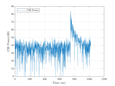
This dataset includes UWB range measurements performed with Pozyx devices. The measurements were collected between two tags placed at several distances and in two different conditions: with Line of Sight (LOS) and Non-Line of Sight (NLOS). The measurements include the range estimated by the Pozyx tag, the actual distance between devices, the timestamp of each measurement and the values corresponding to the samples of the Channel Impulse Response (CIR) after each transmission.
- Categories:
2138 Views
The Geomagnetic field can be used for classifying different landmark locations inside a big building.
- Categories:
435 Views
The file contains raw data collected from 9 pedestrians. Three of them walked in Track 1, another three walked in Track 2 and the last three walked in Track 3. All the pedestrians ended their walks at the starting point. Track 1 and Track 3 cover a distance of 150.3m. While, the Track covers a distance of 111.4m.
- Categories:
313 Views