Land Use Mapping
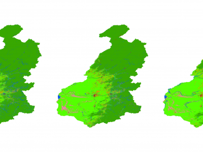
Generating accurate thematic land use maps is importance in ecologically vulnerable regions, especially considering the challenges associated with extracting the forest-steppe ecotone and its associated uncertainties and high error rates. By employing the Principal Component Analysis (PCA) method to integrate Sentinel-1 and Sentinel-2 imagery, high-resolution (10 meters) land use cover products were generated for the forest-steppe ecotone of the Greater Khingan Mountains from 2019 to 2021.
- Categories:
 132 Views
The Dataset
We introduce a novel large-scale dataset for semi-supervised semantic segmentation in Earth Observation: the MiniFrance suite.
- Categories:
5277 Views