UAV

- Categories:
 214 Views
Unmanned aerial vehicles (UAVs) are being used for various applications, but the associated cyber risks are also increasing. Machine learning techniques have been successfully adopted to develop intrusion detection systems (IDSs). However, none of the existing works published the cyber or physical datasets that have been used to develop the IDS, which hinders further research in this field.
- Categories:
1596 Views
In this dataset, we conducted a spectrum monitoring experiment in an urban environment. The helikite flies up to an altitude of 400 feet throughout the day from noon to 9 p.m. during NC State’s Packapalooza festival in August, 2022. The spectrum is swept up to 6 GHz. Every sweep takes around 1 minute, while after every 4 measurements, the 5th measurement takes close to 5 minutes due to another data collection activity running in parallel. The photo of a flying Helikite at the experiment site is shown in the dataset image.
- Categories:
288 Views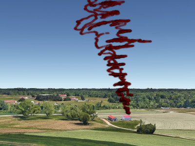
In this dataset, we conduct the spectrum monitoring experiment in AERPAW Lake Wheeler site, which can be classified as a rural area. The helikite flies up to an altitude of 500 feet at increments of 10 meters, while waiting for 5 minutes in between altitude changes. The spectrum is monitored up to 6~GHz. The trajectory of the helikite mapped on top of the experiment site during the flight is in the dataset image. Small random variations in altitude due to wind can also be observed.
- Categories:
146 Views
Air corridors are considered as a promising solution to traffic management of a large number of aircrafts (both manned and unmanned). To enable such a system, we developped an emulation of an air corridor system based on a software in the loop (SITL) from ArduPilot (a popular open source autopilot).
- Categories:
153 Views
Recently, unmanned aerial vehicles (UAVs) have been receiving significant attention due to the wide range of potential application areas. To support UAV use cases with beyond visual line of sight (BVLOS) and autonomous flights, cellular networks can provide connectivity points to UAVs and provide remote control and payload communications. However, there are limited datasets to study the coverage of cellular technologies for UAV flights at different altitudes.
- Categories:
566 Views
This dataset is in support of my research paper - Short Circuit Analysis of 666 Wh Li-Ion NMC
Faults and datasets can be copied to submit in fire cause investigation reports or thesis. The simulation is run for 20 hours (72000 seconds) of simulation time for each fault of 100 faults.
PrePrint : (Make sure you have read Caution.)
- Categories:
2036 Views
In this paper, we develop a hierarchical aerial computing framework composed of high altitude platform (HAP) and unmanned aerial vehicles (UAVs) to compute the fully offloaded tasks of terrestrial mobile users which are connected through an uplink non-orthogonal multiple access (UL-NOMA).
- Categories:
359 Views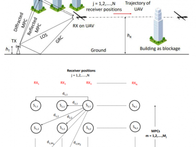
Ground-to-air (GA) communication using unmanned aerial vehicles (UAVs) has gained popularity in recent years and is expected to be part of 5G networks and beyond. However, the GA links are susceptible to frequent blockages at millimeter wave (mmWave) frequencies. During a link blockage, the channel information cannot be obtained reliably. In this work, we provide a novel method of channel prediction during the GA link blockage at 28 GHz.
- Categories:
394 Views
One to three columns of data are X, Y, Z coordinates respectively
- Categories:
430 Views