Remote Sensing

Gorakhpur is a city located in the north-eastern region of
Uttar Pradesh state of India. It is a sub-part of Purvanchal
region of Uttar Pradesh and Bihar. In the south-western
part, Gorakhpur periphery spreads along Rapti river. In
the north-western region, Gorakhpur shares its periphery
with Chillua Tal. In the southern part, Ramgarh Tal with a
perimeter of 18 km is located.
Water Bodies:
+ Ramgarh Tal is a historically important heritage site and
is also a tourist attraction; spread over 700 hectares of
- Categories:
 300 Views
India is a sub-continent that stretches from Ladakh in
the North to Kanyakumari in the South and from
Gujrat in the West to Arunachal Pradesh, Nagaland
and Manipur in the East. India is currently the
seventh largest country by land covering an area of
approximately 32,87,263 kms.
India's Space Strengths:
India is the fourth country in the world to have
destroyed a satellite of its own. India built the
record-breaking space capability of launching 104
satellites on a single Polar Satellite Launch Vehicle
- Categories:
79 Views
This is an indoor environment data set collected from our research team's laboratory, and the data is collected from the Intel RealSense D435i camera. There are a total of 12 datasets, each in the format of a `.bag` file in ROS packet format. Each file contains RGB images and IMU data.
- Categories:
127 Views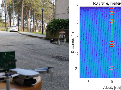
In the attached dataset, a continuous record of 2493 chirp-sequence FMCW radar burst is presented. The data consist of the direct ADC output of an AWR1443BOOST radar board from Texas Instruments during 47.37 s of continuous operation. During this time, two FMCW radars of the model AWR1642BOOST were continuously transmitting sweeps with its main lobe aimed towards the first radar. This produces the apparition of two different uncorrelated interferences at the victim radar side, which can be seen on different indexes of the provided capture.
- Categories:
817 Views
With the increased use of high-spatial-resolution (HSR) images for vegetation monitoring in arid areas, more details of the low vegetation coverage and interference from the land “background” are captured in the corresponding images. From computational time and accuracy, the multi-angle method (MAM) in the pixel dichotomy model is apotential algorithm to apply in arid areas, but MAMneeds the multi-angle vegetation index (VI) as the driver parameters.
- Categories:
352 Views
This dataset provides valuable insights into hand gestures and their associated measurements. Hand gestures play a significant role in human communication, and understanding their patterns and characteristics can be enabled various applications, such as gesture recognition systems, sign language interpretation, and human-computer interaction. This dataset was carefully collected by a specialist who captured snapshots of individuals making different hand gestures and measured specific distances between the fingers and the palm.
- Categories:
749 Views
This dataset has 32,000 remote sensing images in UAV scenes of tiny objects with labels.
- Categories:
213 Views
This dataset consists of high-resolution visible-spectrum (RGB) and thermal infrared (TIR) images of two vineyards (Vitis vinifera L.) with varieties of Mouhtaro and Merlot, which was captured by Unmanned Aerial Vehicle (UAV) carrying TIR and RGB sensors three times in a cultivation period.
- Categories:
508 Views
Data related to figures 3 and 7 in T. Fordell, K. Hanhijärvi, A.E. Wallin, J. Myyry, T. Lindvall ”Out-of-Band Fibre-Optic Time and Frequency Transfer Using Asymmetric and Symmetric Opto-Electronic Repeaters”, IEEE
IEEE Trans. Ultrason. Ferroelectr. Freq. Control (2023).
- Categories:
42 Views
Development of the Complex-Valued (CV) deep learning architectures has enabled us to exploit the amplitude and phase components of the CV Synthetic Aperture Radar (SAR) data. However, most of the available annotated SAR datasets provide only the amplitude information (Only detected SAR data) and disregard the phase information. The lack of high-quality and large-scale annotated CV-SAR datasets is a significant challenge for developing CV deep learning algorithms in remote sensing.
- Categories:
1190 Views