Geo-Sensing

This dataset was obtained from the ionogram at Kupang in 2022 to investigate the frequency window of the Near Vertical Incidence Skywave (NVIS) channel with homogenous Time of Flight (ToF) values. All data is in the form of.mat files (MATLAB). The first dataset is in Matlab variables ('DataWidthFrekHourly','DataCenterWidthFrekHourly'), which consist of maximum window frequency values with homogenous ToF and the center frequency of the widest window. The structure of the data array is 96x365, with the row as the time (1:96) and the column as the day in one year (1:365).
- Categories:
 23 Views
We employed Hexacopter unmanned aerial vehicle (UAV) equipped with the SPECIM FX17E hyperspectral camera to implement ultra-low-altitude flight aerial photography missions with atmospheric correction processing. We collected three hyperspectral images and combined them into three data pairs, which exhibit varying degrees of spectral shift. Among them, a hyperspectral image including six types of ground objects was collected in Changsha at 4:00 pm on September 27, 2021, with sunny weather and a flight altitude of 30m, named CSSunny.
- Categories:
99 Views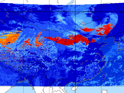
Since meteorological satellites can observe the Earth’s atmosphere from a spatial perspective at a large scale, in this paper, a dust storm database is constructed using multi-channel and dust label data from the Fengyun-4A (FY-4A) geosynchronous orbiting satellite, namely, the Large-Scale Dust Storm database based on Satellite Images and Meteorological Reanalysis data (LSDSSIMR), with a temporal resolution of 15 minutes and a spatial resolution of 4 km from March to May of each year during 2020–2022.
- Categories:
537 Views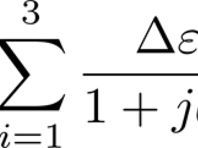
The dataset contains fitted three-pole Debye dielectric model parameters of 567 soil spectra. Three soils of loamy sand, sandy loam, and silt loam textures were tested. Of each soil, 20 samples of various water contents were prepared with the use of distilled water and potassium chloride solutions, 5 samples for each liquid. Air-dry samples were also prepared. Dielectric spectra were obtained with the use of a six-channel coaxial-transmission-line cell system at 9 controlled temperature steps from 0.5 to 40°C in the 0.02 – 3 GHz frequency range.
- Categories:
143 Views
Gorakhpur is a city located in the north-eastern region of
Uttar Pradesh state of India. It is a sub-part of Purvanchal
region of Uttar Pradesh and Bihar. In the south-western
part, Gorakhpur periphery spreads along Rapti river. In
the north-western region, Gorakhpur shares its periphery
with Chillua Tal. In the southern part, Ramgarh Tal with a
perimeter of 18 km is located.
Water Bodies:
+ Ramgarh Tal is a historically important heritage site and
is also a tourist attraction; spread over 700 hectares of
- Categories:
300 Views
India is a sub-continent that stretches from Ladakh in
the North to Kanyakumari in the South and from
Gujrat in the West to Arunachal Pradesh, Nagaland
and Manipur in the East. India is currently the
seventh largest country by land covering an area of
approximately 32,87,263 kms.
India's Space Strengths:
India is the fourth country in the world to have
destroyed a satellite of its own. India built the
record-breaking space capability of launching 104
satellites on a single Polar Satellite Launch Vehicle
- Categories:
79 Views
Radio Frequency (RF) signals transmitted by Global Navigation Satellite Systems (GNSS) are exploited as signals of opportunity in many scientific activities, ranging from sensing waterways and humidity of the terrain to the monitoring of the ionosphere. The latter can be pursued by processing the GNSS signals through dedicated ground-based monitoring equipment, such as the GNSS Ionospheric Scintillation and Total Electron Content Monitoring (GISTM) receivers.
- Categories:
137 Views
Perth-WA is the localization dataset that provides 6DoF annotations in 3D point cloud maps. The data comprises a LiDAR map of 4km square region of Perth Central Business District (CBD) in Western Australia. The scenes contain commercial structures, residential areas, food streets, complex routes, and hospital building etc.
- Categories:
324 Views
Ground Penetrating Radar (GPR) has a wide range of applications such as detection of buried mines, pipes and wires. GPR has been used as a near-surface remote sensing technique, and its working principle is based on electromagnetic (EM) wave theory. Here proposed data set is meant for data driven surrogate modelling based Buried Object Characterization. The considered problem of estimating geophysical parameters of a buried object is 2D. The training and testing scenarios include B-scan images (2D data), which contain 16 pairs of A-scan (concatenated forms of A-scans).
- Categories:
583 Views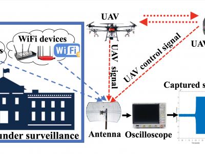
This article presents the details of the Cardinal RF (CardRF) dataset. CardRF is acquired to foster research in RF- based UAV detection and identification or RF fingerprinting. RF signals were collected from UAV controllers, UAV, Bluetooth, and Wi-Fi devices. Signals are collected at both visual line-of-sight and beyond-line-of-sight. The assumptions and procedure for the data acquisition are presented. A detailed explanation of how the data can be utilized is discussed. CardRF is over 65 GB in storage memory.
- Categories:
5526 Views