Geoscience and Remote Sensing

The InSAR processing result,GPS result,gray model predicted result and Gray-Markov model predicted result
- Categories:
 47 Views
TBD
- Categories:
100 Views
The SPYSTUF hyperspectral data contains high spatial and spectral resolution Aisa Eagle II (visible to near infrared, 400-900 nm) airborne imaging spectrometer above a Hyytiälä forest research station hosting the SMEAR II (Station for Measuring Ecosystem-Atmosphere Relations, 61°50' N, 24°17' E) on 3 July 2015. The spectral resolution of the data is 4.6 nm, and the spatial resolution 0.6 m.
- Categories:
866 Views
WITH the advancement in sensor technology, huge amounts of data are being collected from various satellites. Hence, the task of target-based data retrieval and acquisition has become exceedingly challenging. Existing satellites essentially scan a vast overlapping region of the Earth using various sensing techniques, like multi-spectral, hyperspectral, Synthetic Aperture Radar (SAR), video, and compressed sensing, to name a few.
- Categories:
1344 Views
WITH the advancement in sensor technology, huge amounts of data are being collected from various satellites. Hence, the task of target-based data retrieval and acquisition has become exceedingly challenging. Existing satellites essentially scan a vast overlapping region of the Earth using various sensing techniques, like multi-spectral, hyperspectral, Synthetic Aperture Radar (SAR), video, and compressed sensing, to name a few.
- Categories:
419 ViewsWITH the advancement in sensor technology, huge amounts of data are being collected from various satellites. Hence, the task of target-based data retrieval and acquisition has become exceedingly challenging. Existing satellites essentially scan a vast overlapping region of the Earth using various sensing techniques, like multi-spectral, hyperspectral, Synthetic Aperture Radar (SAR), video, and compressed sensing, to name a few.
- Categories:
272 Views
With the advancement in sensor technology, huge amounts of data are being collected from various satellites. Hence, the task of target-based data retrieval and acquisition has become exceedingly challenging. Existing satellites essentially scan a vast overlapping region of the Earth using various sensing techniques, like multi-spectral, hyperspectral, Synthetic Aperture Radar (SAR), video, and compressed sensing, to name a few.
- Categories:
285 ViewsWith the advancement in sensor technology, huge amounts of data are being collected from various satellites. Hence, the task of target-based data retrieval and acquisition has become exceedingly challenging. Existing satellites essentially scan a vast overlapping region of the Earth using various sensing techniques, like multi-spectral, hyperspectral, Synthetic Aperture Radar (SAR), video, and compressed sensing, to name a few.
- Categories:
317 Views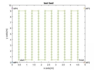
Data are collected on a 5m×10msized test bed, which is set up at Kadir Has University,Istanbul. Wireless access points are located around the corners of the testbed and markers are placed at every 45 cm. RSSI measurements done on the grid shown in Figure are stored via NetSurveyor program running on a Lenovo IdeapadFLEX 4 laptop, which has an Intel Dual Band Wireless-AC8260 Wi-Fi adaptor.At each measurement point, RSSI data are collected for1 min with a sampling interval of 250 ms.
- Categories:
777 Views
The datasets in the compressed file were used in the case study of the article entitled Automated Machine Learning Pipeline for Geochemical Analysis by Germán H. Alférez, et al. Our approach was evaluated with a compositional dataset from 6 fault-separated blocks in the Peninsular Ranges Province and Transverse Ranges Province. The Peninsular Ranges are a group of mountain ranges, stretching from Southern California to Southern Baja California, Mexico. North of the Peninsular Ranges Province is the east-west Transverse Ranges Province.
- Categories:
286 Views