Remote Sensing

Modern science is build on systematic experimentation and observation. The reproducibility and replicability of the experiments and observations are central to science. However, reproducibility and replicability are not always guaranteed, sometimes referred to as 'crisis of reproducibility'. To analyze the extent of the crisis, we conducted a survey on the state of reproducibility in remote sensing. This survey was conducted as an online survey. The answers of the respondents are saved in this dataset in full-text CSV format.
- Categories:
 218 Views
Synthetic Aperture Radar (SAR) images can be extensively informative owing to their resolution and availability. However, the removal of speckle-noise from these requires several pre-processing steps. In recent years, deep learning-based techniques have brought significant improvement in the domain of denoising and image restoration. However, further research has been hampered by the lack of availability of data suitable for training deep neural network-based systems. With this paper, we propose a standard synthetic data set for the training of speckle reduction algorithms.
- Categories:
3149 Views
This aerial image dataset consists of more than 22,000 independent buildings extracted from aerial images with 0.0075 m spatial resolution and 450 km^2 covering in Christchurch, New Zealand. The most parts of aerial images are down-sampled to 0.3 m ground resolution and cropped into 8,189 non-overlapping tiles with 512* 512. These tiles make up the whole dataset. They are split into three parts: 4,736 tiles for training, 1,036 tiles for validation and 2,416 tiles for testing.
- Categories:
330 Views
deleted
- Categories:
52 Views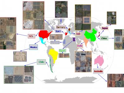
Extracting the boundaries of Photovoltaic (PV) plants is essential in the process of aerial inspection and autonomous monitoring by aerial robots. This method provides a clear delineation of the utility-scale PV plants’ boundaries for PV developers, Operation and Maintenance (O&M) service providers for use in aerial photogrammetry, flight mapping, and path planning during the autonomous monitoring of PV plants.
- Categories:
1326 Views
Many applications benefit from the use of multiple robots, but their scalability and applicability are fundamentally limited when relying on a central control station. Getting beyond the centralized approach can increase the complexity of the embedded software, the sensitivity to the network topology, and render the deployment on physical devices tedious and error-prone. This work introduces a software-based solution to cope with these challenges on commercial hardware.
- Categories:
433 Views
Accurate information about crop rotation is essential for administrators, managers and various government departments for assessment, monitoring, and management of various resources for crop escalation. Radar remote sensing, because of its all-weather capability and assured uninterrupted data supply can show a substantial part in the evaluation of crop rotation.
- Categories:
866 Views
This data package is parepared by Dr. Jianguo Niu (IMSG at NOAA NESDIS/STAR) on
March 18, 2020
The purpose of this OMPS LFSO2 retrieval products package is in support the paper:
"Evaluation and Improvement of the Near-real-time Linear Fit SO2 retrievals from Suomi NPP (S-NPP) Ozone Mapping & Profiler Suite"
This package includes LFSO2 V8TOS retrievals of:
1. "logic swith on" (original set as described by th paper 01824) products
- Categories:
187 Views
About
Dataset described in:
Daudt, R.C., Le Saux, B., Boulch, A. and Gousseau, Y., 2019. Multitask learning for large-scale semantic change detection. Computer Vision and Image Understanding, 187, p.102783.
This dataset contains 291 coregistered image pairs of RGB aerial images from IGS's BD ORTHO database. Pixel-level change and land cover annotations are provided, generated by rasterizing Urban Atlas 2006, Urban Atlas 2012, and Urban Atlas Change 2006-2012 maps.
The dataset is split into five parts:
- 2006 images
- Categories:
16289 Views
Subpixel classification (SPC) extracts meaningful information on land-cover classes from the mixed pixels.However, the major challenges for SPC are to obtain reliable soft reference data (RD), use apt input data, and achieve maximum accuracy. This article addresses these issues and applies the support vector machine (SVM) to retrieve the subpixel estimates of glacier facies (GF) using high radiometric-resolution Advanced Wide Field Sensor (AWiFS) data. Precise quantification of GF has fundamental importance in the glaciological research.
- Categories:
1328 Views